
Introduction
Both of Japan and China had national isolations,and westernization reformations during 19th century. Although both of them were forced to open their gates and sign numerous unjust treaties by western countries, only Japan turned to a powerful country through their reformation after, and China was nibbled by great powers. At pre-modern era, the two countries had totally different altitudes toward western civilization, which lead to their different national fates.
The map that I picked is just a witness of such an ironical time about East Asia. Times have passed and circumstances have changed, but the map is still lying on museum’s display table and telling us this history silently. Through my research, I want to explore how Japan and China’s altitudes toward pre-modern western civilization’s impact effected the two countries’ modernizations, and why only Japan succeed.
The Map’s History
This is the map I picked in UBC’s museum called地球萬國山海輿地全圖説(Chikyū bankoku sankai yochi zenzusets).
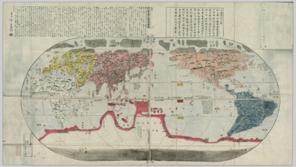
Chikyū bankoku sankai yochi zenzusetsu (1790), the map copy of坤輿万国全図
It was created by Nagakubo, Sekisui (1717-1801) in 1790 (UBC, 2015). It was based on Ricci, Matteo (1552-1610)’s 坤輿万国全図, the main character of this paper.
坤輿万国全図 was the most advanced world map in 17th century. It was imported to Japan from China in early isolation era, colored and marked by some katakana annotations.
Unattributed (1604?), two page colored Japanese copy of the 1602 map
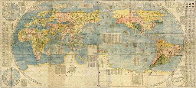
The original Chinese version was created by the Christian missionary, Matteo Ricci, in 1602 with the assistance from 李之藻 (1565-1630), the minister and scientist in the Ministry of Works in feudal China (Ming Dynasty) (日本の世界地図(1)発見の時代~坤輿万国全図 写図, 2011). It was a very large map with the size of 1.8x4M, and carved on six large blocks of wood.


Kunyu Wanguo Quantu, printed by Matteo Ricci, Zhong Wentao and Li Zhizao, upon request of Wanli Emperor in Beijing, 1602
This map was surprisingly accurate, and detailed, so that some people even doublet its facticity (锐尺, 2014). This is understandable if we consider the measuring/mapping technique in early 17th century. At that time, Australia and Antarctica were still not found yet, and Magellan’s trip around the world just passed 80 years. As a matter of course, people will be surprised that a missionary could utilize old time’s mapping technique to create such a modern-like map which we made by using satellites. Not only about continents and 2 polar, it explains the cause of eclipses and the rotating system of earth and moon as well.
Matteo Ricci was one of the pioneers of Catholic missionary in China and the first Western scholar who read Chinese literature and studied Chinese ancient books. Except doing missionary works, he also tried to keep in touch with officers and society people, and spread the Western astronomy, mathematics, geography and other scientific knowledge (锐尺, 2014). His writings not only made important contributions to the exchanges between China and the West, but also had a significant impact on the understanding of Western civilization on the Japanese and Korean, such as this geographical map. He combined Chinese and western measuring and marine technology to contribute this most advanced world map based on former maps.
Different Encounter in China And Japan
Unfortunately,Chinese rulers didn’t take this significant map seriously. This map was published in late Ming dynasty. But Ming was replaced by Qing in 1636. In Qing dynasty, emperor and government ministers lost their passion on western culture and modern technologies. They couldn’t distinguish Spain and Portugal, and even made mistake to recognize France. But those were ready-made knowledge on this map, from former dynasty. In Qing Dynasty, people’s deficit about nature science completely unmasked in many ways.
In Kangxi period, the minister Guangxian Yang, criticized ‘Round earth theory’ that: “有识者以理推之,不觉喷饭满案矣。夫人顶天立地,未闻有横立倒立之人也。……此可见大地之非圆也” (锐尺, 2014). It means that if earth is a round, then the person stands above the round and anther person stands below the round will be standing opposite, so one of them must be hanging upside down, which is impossible. It can be seen that Chinese people were not able to understand gravity, no speaking of solar system which denied Chinese believe: our world is the central of the universe. Thus, this map was a treason for Qing government. 地球, the most common Chinese character in todays’ world were definitely a traitorous word in 17th century’s China. The word, 地球 was firstly introduced by Ricci on this map in history (锐尺, 2014). It overturned Chinese people’s traditional concept of the world: round universe and square earth.
It was also a bad word for Qing’s empire. For example, Asia was marked as 亚细亚. In Qing’s famous scholar Pingbu Qing’s book,he interpreted it as an insult. Because the word, 亚 in Chinese means secondary, lowliness, and loser. In former dynasty, Ming, the government minister Guangqi Xu cooperated with Matteo Ricci to translate one of the modern science’s footstones: ‘Elements of Geometry’ (98绿茶, 2008). But in Qing dynasty, what Ricci’s works got, were only ignorance and ridicule. The sorry decline of Chinese people’s scientific spirt made their country far behind the world later, and their governing class had inevitable responsibility.
In contrast, this map was a reference of geographic knowledge in Japan. It became the most important template of map creation. Just after one year of map坤輿万国全図’s first publish, it was imported to Japan in 1603~1606. This map with Chinese characters was much more popular than other EU-made maps in Japan, and it was considered as the only reliable world map, and became the most important information source for later works, especially during close country period (坤輿万国全図).
The Difference of China and Japan’s Revolution
China is the Heaven country, which has vast territory and abundant resources, such a though rooted in Qing rulers’ heads. They didn’t care westerners came to China for culture exchange or business or what. Pre-modern western civilization couldn’t catch Qing emperors’ eyes, except weapon s. In late Qing dynasty, similar to Japan, China was facing inside national conflicts and the threat of outside colonialism, in order to maintain the Qing’s dominant position, some ministers lead China’s modernization movement as well. But the difference was, Japan’s Meji restoration was started from lower worriers. The unfair promotion system, the busted economy, and countless never-seen western technology made them have no choice to down the Bakufu. What they need is a powerful modern country, a new world, but not a decayed old government.
During isolation period, Tokugawa government opened Nagasaki bay, allowed Dutch and Chinese had trades there. The government ordered coming businessmen need to write reports about overseas’ information. Such as風説書 fusetsugaki (于忠元, 2013) . During 1840-1844 the風説書 about China even reached 19 books, through those reports Japanese governing class realized the unprecedentedly national crisis that eastern people were facing (于忠元, 2013). Edo people were curious about how world was changing. But Qing government thought China was still the strongest, most advanced country in the world.
In the aspect of psychology, Chinese and Japanese were different as well. For a long term, China was the absolute leader in Asia as a culture exporter. Chinese emperors called surrendering countries as the lands of the barbarians. During the 30 years of Chinese westernization, Chinese publisher’s books about western learning only were sold about 13000 books. But in Japan, only books about western learning which written by Fukuzawa Yukichi were sold over 250,000 books (黎询洲, 2013). Just because Japan did not have the superiority complex towards foreign countries, so Japanese people could accept western learnings without hesitation.
Conclusion
In Matteo Ricci’s notes, he commented that arrogance and being conservative brought China unfortunate fate; based on the greatness, political institution, and the fame of scholarism, they regarded other nations as savages, but such an innocence would make them arrogant. Obviously, only looking far ahead and following the trend of times could make a country progress. That is so called Chinese traditional virtue: modesty. As a powerhouse, he must keep awake from his power; once he lost in it, the day of his death is not far. If we enlarge the scale of time, there is no permanent advanced countries, but only permanent developing countries.
References
98绿茶. (2008/7). 《坤舆万国全图》见证了清朝时期可悲的倒退. Access time: 2017/4/1,铁血网: http://bbs.tiexue.net/post2_2946086_1.html
UBC. (2015). Chikyū bankoku sankai yochi zenzusetsu. Access time: 2017/4/5, Japanese Maps of the Tokugawa Era: https://open.library.ubc.ca/collections/tokugawa/items/1.0213204#p0z-5r0f:%E4%B8%87%E5%9B%BD
坤輿万国全図. Access time: 2017/4/4, 世界史の窓: http://www.y-history.net/appendix/wh0801-103.html
黎询洲. (2013). 中日“闭关锁国”时期的文化心理之比较. Theoretic Observation (79), Page 40.
日本の世界地図(1)発見の時代~坤輿万国全図 写図. (2011年9月27日). Access time: 2017/4/2, 泰西古典絵画紀行:
http://blog.goo.ne.jp/dbaroque/e/2aac5de801e476215d496d83e3909433
锐尺. (2014/10). 《坤舆万国全图》:一张明代的世界地图. Access time: 2017年4月6日,National Geographic: http://www.nationalgeographic.com.cn/news/2190.html
于忠元. (2013). 中日“闭关锁国”时代对西方态度之比较. Forward Position (328), Page 150.
Contributor: Yiran
(April 10, 2017)

You must be logged in to post a comment.