
Ezo: the familiar foreign land
Ezo refers to the northernmost Japanese island currently named Hokkaido, which did not officially become part of the country till 1868.
The origin for the name Ezo is still very much debated whether it came from Ainu language or from the other Japanese origins. Tokugawa Japan saw the land of Ezo as a vast space habited by Ainus divided into higashi Ezo (east), Nishi Ezo (west), (north) kita Ezo and Oku Ezo (which includes the most northern part including the current Russian Sakhalin islands).
While most of the Island was originally habited by the Ainu people the first Japanese mainlanders in Ezo territory can be recorded back to 12th century where various escapees such as Minamoto no Yoshitsune, found refuge in 1189 after being defeated by his brother Yoritomo. Slowly Japanese merchants began to enter the Island to establish a trade network with the local population with the requirement of paying a tax to the Island governor of the Matsumae household, which granted the added privilege of building houses known as unjōya with the purpose of trading among the local population. The Matsumae being an official daimyo house was based on the most southern tip of the Island as only two percent of the total population belonged to the Wajin-chi (Japanese land people), whom mostly stayed in the southern region near the mainland, while the rest of the Island was mostly considered to be habited by the Ainu people who had continuously immigrated further north as the Japanese started to settle. Thus the Matsumae became the official point of contact between the Japanese mainland and Ezo. The first time Ezo appeared on a map was on a Korean map made in 1471 in Kaito shokoku sozu . While areas such as Ezo and the Ryuukyu islands were traditionally considered as foreign domains in the diplomatic discourse, the inclusion of Ezo in Japanese maps certainly lent itself as an excuse for the gradual integration of this Island to the Japanese nation in more recent times, yet it is clear that most of the land was considered mostly exotic and foreign. It was only starting after 1802 that Ezo began to enter the interest of the Edo government when a magistracy in Hakodate was built in order to connect the northern area bureaucracy to the capital. With this new office the integration policy for the Ainus was put into place, modern infrastructures were built and slowly the Island was integrated into the greater country. Overall what really striped the Ainus of their political autonomy was the state sanctioned vaccinations and health care where the Japanese saw themselves as the superior race in need to civilise the ‘barbarians’ who were neither descendant of Western or Chinese traditions.
Mapping Ezo in Tokugawa maps (how did the representation of Ezo change through time?):
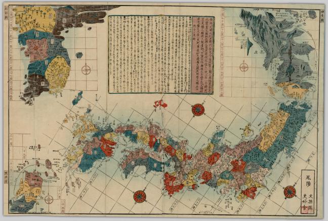
The first map we will take a look at is the Dai Nihon setsujō sangoku no zenzu which depicts the main Japanese territories such as Honshu and kyushu islands, including both the Korean peninsula and Ezo. Published in 1816 by Kiyudo Kyokueido it is a case map folded inside a cover book style with a sizing of 25cm by 18cm, probably made for convenient travel and storage. When stretched out the map becomes 46cm by 69 cm, which gives the observer much detail on what region they wish to focus on. It is a Wood block print oriented with the north to the upper right and includes details on distances of the different sea routes.
As can be seen in the above image what is of most interest is the fact that while Korea seems to be thoroughly detailed with numerous cities and towns listed, Ezo remains a mystery as not only it is covered in dark colors, reminiscing its cold atmosphere, but it is also much more sparse in detailing. The overall shape is geographically smaller and wrong compared to our contemporary understandings and its overall location, being that it directly parallels Korea’s position is also odd. What is interesting though is that the southern most region of Ezo is colored in yellow which suggests a clear connection with the Japanese peninsula known as Wajinchi (Japanese people land) compared to the rest of the territory which was considered Ezochi meaning inhabited exclusively by Ainu populations. Only the Ainu’s which originally lived in the newly Wajinchi land were allowed to stay in these territories. This difference in portraying the two sides of Ezo are very much intentional as back in those days there was a clear dividing line established between the two areas with military personnel (bansho) rejecting any Japanese who didn’t have proper travel papers to pass. It is thought that this strict division was put in place to reduce the conflicts between the two ethnic groups but scholars argue that the Matsumae intentionally hid the potential mineral resources of the land to the central bakufu government in order to keep its privileged ruling position on the Island.

Later more focused and detailed depictions of Ezo can be seen in the Ezo zu map by Orihashi Shun made in 1829. The map is a large watercolor representation of not only the geographical Ezo territories, but in the corner right also has a depiction of an Ainu hunter and his wife.
While the actual size of Ezo is still incredibly smaller compared to current knowledge on Hokkaido topography and is very much divided into many small pieces, it still gives us a glimpse of the way the Tokugawa government may have perceived this region.
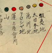
The map is equipped with a legend at the bottom that shows what each color is supposed to represent. Dark red represents Ezo chi, yellow Dai nihon (Japanese land), grey Manchuria, beige Russia, bright red trading points and green mountains.
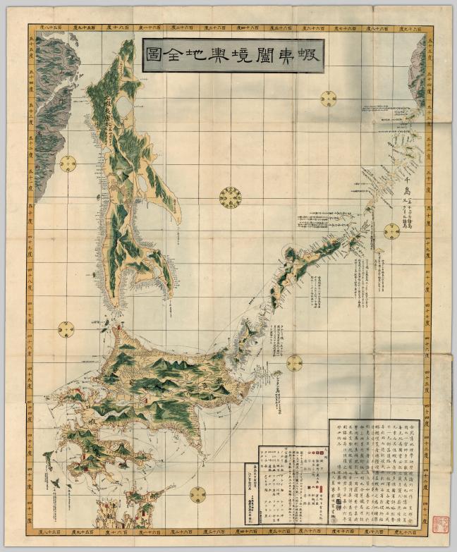
Modern interpretations of Ezo closely resembling today’s view of the land become more apparent in the 1850’s as can be seen by the above map named Ezo kōkyō yochi zenzu created by Fujita Ryo in 1854. The map was made using woodcut prints with an overall size of 91.7 cm to 113.2 cm foldable into 10 sheets, with parallels and meridians portrayed. In this modern interpretation of Ezo we can see that the Island had essentially become part of the Japanese territory, as there was no more distinguishing between Japanese and Ainu land. In addition the shape and size along with the extensive details of the topography of the place clearly suggest that more exploration had been done by the Bakufu of this land, making the area less mysterious than in the past. The color schemes used in this map clearly integrate Ezo into the rest of the Japanese territories.
Notes:
De Palma, Daniela. “Ricerche Sulla Cartografia Di Ezo.” Rivista Degli Studi Orientali 71 (1997): 1-123
Keene, Donald. The Japanese discovery of Europe, 1720-1830. Stanford University Press, 1969.
Walker, Brett L. The conquest of Ainu lands: ecology and culture in japanese expansion, 1590-1800. Berkeley: University of California Press, 2001.
Wigen, Kären, Fumiko Sugimoto, and Cary Karacas. Cartographic Japan: a history in maps. Chicago: University of Chicago Press, 2016.
Yonemoto, Marcia. Mapping early modern Japan: space, place, and culture in the Tokugawa period (1603-1868). Berkeley: University of California, 2005.
Contributor: Camilla
March 27, 2017

You must be logged in to post a comment.