
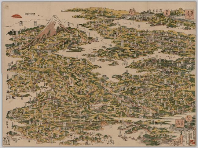
The Tōkaidō meisho ichiran (1818) or “Famous Places on the Tōkaidō Road in One View” by Katsushika Hokusai (1760-1849) is a woodblock print of the famous places along the Tokaido Road. This seems to be more like a landscape painting or picture. The Tōkaidō meisho ichiran is also highly distorted. These distortions and the map’s picturesque form prompted me to ask questions. What are the reasons for these distortions? Is this map a picture or is it functional? What is the significance of a map of this style? In this blog post, I will answer these questions by looking into the background of the Tōkaidō Road, the author of the map, and the particular style of the map.
Introduction to the Tokaido Highway
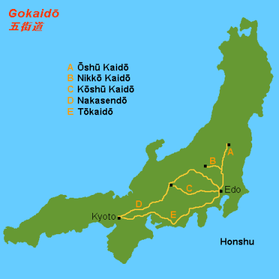
The Tōkaidō Road or Highway was one of the five main roads/highways in Japan during the Tokugawa period. It was a route with 53 stations connecting Kyoto to Edo. During the Tokugawa period, the Tōkaidō was the “most important route of the country” during the Tokugawa period (Tragnanou 2004: 1). It was known to be a “space of play and release” and “the locus of famous places (meisho)” (Ibid.). Eventually, a railway was established in 1889 that ran parallel to the road and “almost eradicating the use of the highway” (Ibid.). Despite the railway, the road has been revered and its legacy can be seen in the many visual and literal representations.
During the Tokugawa period and the Meiji period, “the Tōkaidō was a popular subject of representation and was depicted in a variety of visual and literary media” (Ibid.). Some visual representations include Utagawa Hiroshige’s “The Fifty-Three Stations of the Tōkaidō” and Katsushika Hokusai’s “53 Stations of the Tōkaidō”. Literal representations include the famous novel, Tōkaidōchū Hizakurige or Shank’s Mare. In this blog post, I will be focusing on one particular map representation of the road, the Tōkaidō meisho ichrian, by Katsushika Hokusai.
About the Author, Hokusai
Katsushika Hokusai, or more widely known as “Hokusai”, was an artist who lived during the Tokugawa period and is “among the best-known names in Japanese art” (Screech 2012: 103). Hokusai is very well known and very well loved by many all over the world. Hokusai specialized in the okiyo-e genre and is most famous for his “Great Wave off Kanagawa” which has become very famous as an iconic symbol of Japan in the Western world (Screech 2012). He is also known for his “36 Views of Mount Fuji”, “100 Views of Mount Fuji”, erotic prints or shunga, and his “manga”.
During Hokusai’s career, which “spanned 7 decades”, Hokusai took on “more than 30 different names” that usually changed according to the change in his “artistic style and technique” (Breedlove 2016: 1143). For example, at one point he called himself, “the Art-Crazy Old Man”. While taking on different names was common for Japanese artists, Hokusai changed his name “more often than any other major Japanese artist” (Ibid).
Hokusai has created other maps like the Sobo kairiku shokei kiran, the Oshu Shiogama Matsushima no ryakazu, and his bird’s eye map of China. Although his work is very famous, his maps are not that well known and have not been studied in great lengths. However, it is important to consider that Hokusai excelled in painting landscapes and people. He was not a cartographer.
Background of the Map & Distortions
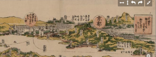
Hokusai’s Tōkaidō meisho ichiran or “Famous Places on the Tokaido Road in One View” was created in 1818 and is a woodblock print of the famous Tokaido road. According to the metadata, this map depicts towns and castles. It also depicts notable landmarks such as Nihonbashi in Edo, Kyoto, and Mount Fuji.
This map is highly distorted as seen in the positioning of these landmarks. For example, Edo and Kyoto are both depicted on the west or right side of the map with Edo on the bottom right corner and Kyoto on the top right corner. Mount Fuji is depicted in the top left on the east side of the map. In comparison to a modern map of the Tokaido, Kyoto, on the east, is opposite of Edo, which is on the west and Mount Fuji is closer west near Edo. It is almost as if Hokusai curled up the road in a circular/mandala shape. One can definitely see how Hokusai took many liberties in how he depicted the road.
Understanding the style of this map is important in order to understand the distortions, what this map, and others like it, might have been used for, and the significance of maps of this style.
Panoramic style
The map depicted below is another picturesque map of the Tōkaidō. It is called Shinkoku kaisei Tōkaidō saiken ōezu (1800) Shōtei Kinsui.
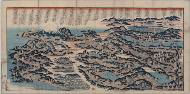
These kinds of maps use the style that scholar Jilly Traganou terms as the panoramic style. These kinds of panoramic picture maps were to be approached first as “primarily visual” focused on the macro scale and then as “texts” focusing on their micro scale. The panoramic style or approach came about through the influence of artists interest in a combination of two kinds of views: the realistic view and the illusionist view. The realistic representation is a view that is based on the “capacities of the human eye” of being able to view landscapes from a “macroscopic perspective” (Traganou 2013: 185). In the Tōkaidō meisho ichiran this view can be seen in how “a hypothetical vista of the whole route at a glance” is created (Ibid.: 187). The illusionist view is “expand[ing] the eye’s capabilities” through devices like a microscope or telescope, “to penetrate into the microcosm of life within its separate parts” (Ibid.: 185). This view can be seen through the tiny details of the road, the buildings depicted on the side of it, and ports and boats in the water.
Reasons for distortions
With knowledge of the panoramic style that the Tōkaidō meisho ichiran takes on, one can discover some reasons for the distortions. A reason for the distortions could simply be because, as a painter of landscapes and not a cartographer, Hokusai may not have been thinking of being precise. One could argue that this map is just another one of his views of Mount Fuji as it is a focal point on the map. Since this style of map was to be approached first visually, the reasons for the distortions could be just “decorative rather than technical” (Ibid.: 187). However, even though there are many distortions, Traganou writes that “both the sequence of place-names and the intersection of the road with major points such as bridges and lacks correspond to reality” (Ibid.). Therefore, as a tourist or itinerary map, this would be perfectly functional. In fact, with Tōkaidō being very popular for travel, there was a lot of traffic so there may have been no need for a map. In Shank’s Mare, a comedic novel of Yaji and Kita, two men traveling to Ise Shrine, there is no mention of the two referring to maps. Instead, they follow or ask innkeepers and fellow travelers for directions. Traganou also writes that in contrast to horizontal scroll maps, these panorama style maps “convey the sense of a labyrinthine journey” (Ibid.). For travel writers whose writings were characterized as an “‘encounter with difference and otherness’ or a ‘confrontation with…alterity’”, the map’s distortions could have been beneficial (Laffin 2018: 2).
The significance of a map of this style
As mentioned, the significance of a map of this style could be just for decorative purposes. Perhaps, it also presents itself as an effective tourist map as the places are in the correct sequence and the distortions convey a wandering labyrinthine journey that tourists and travel writers may have liked. However, Traganou writes of the significance of the panoramic style in creating maps that are symbolic of Japan as a nation. She writes that the landscape of the road is being “superimpose[d] […] upon the land(-scape) of the nation” (Traganou 2013: 187). If we look at the Tōkaidō meisho ichiran, the road covers most of the land; it fills the land mass. Therefore, the road makes up the land; the road is the land. In contrast, the modern map depicts the Tōkaidō road taking up only a portion of the land of Japan and not the entire land mass. This idea of the Tōkaidō meisho ichiran and other panoramic maps as being symbolic of Japan through superimposition is very interesting especially when one takes a closer look at a modern Japanese map. If one imagines the modern map of Japan and curls it in a circular/mandala shape, one can see how it could look very similar to the landmass of the Tōkaidō meisho ichiran. In this way Traganou argues that this depiction of the Tōkaidō, though geographically distorted, is symbolic of the nation. Traganou furthers this argument by pointing out the presence of Mount Fuji on the map. Mount Fuji in “its eminent, central position connotes symbolically the whole nation” (Ibid.).
The Tōkaidō meisho ichiran by Katsushika Hokusai is a panoramic map of many distortions. Though it is distorted, the map would have functioned as an excellent tourist map for anyone traveling along the Tōkaidō Road. The map also exemplifies the importance of the Tōkaidō Road to the Tokugawa shogunate as it is presented as symbolic of the nation of Japan.
Bibliography
Breedlove, Byron and Jared Friedberg. “Perspective and Surprise in the Floating World.” Emerging Infectious Diseases 22, no. 6 (2016): 1143-1144.
Laffin, Christina. “Premodern Japanese Travel Diaries.” In The Ashgate Research Companion in Travel Writing, edited by Alasdair Pettinger and Tim Youngs. London: Ashgate Publishing, 2018.
Screech, Timon. “Hokusai’s Lines of Sight.” Mechademia 7, (2012): 103-109.
Traganou, Jilly. “Representing Mobility in Tokugawa and Meiji Japan.” In Japanese Capitals in Historical Perspective: Place, Power and Memory in Kyoto, Edo and Tokyo, edited by Nicolas Fieve and Paul Waley, 6. New York: RoutledgeCurzon Taylor & Francis Group, 2013.
Traganou, Jilly. The Tokaido Road: Travelling and Representation in Edo and Meiji Japan. New York: RoutledgeCurzon Taylor & Francis Group, 2004.

You must be logged in to post a comment.