
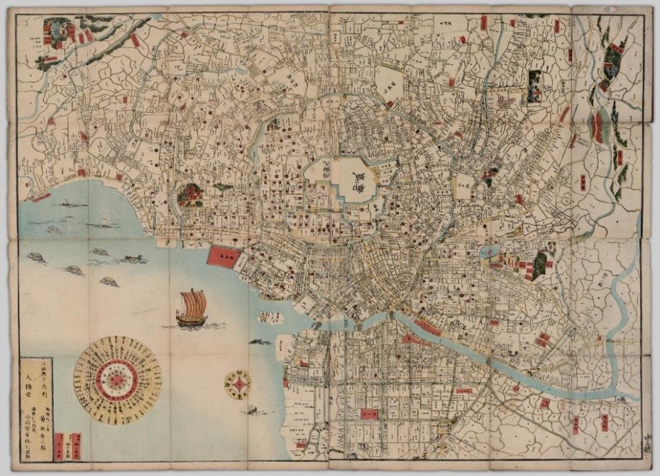
The Edo ezu, also known as the Map of Edo, was created by Kōzaburō Kikuya in 1864 (Kikuya, 1864). In this map, features such as roads, castles, palaces, shrines, temples, and bodies of water were indicated. Edo had a long history and played an important historical role in Japan. In 1590, Tokugawa Ieyasu, a chief vassal of the national military, moved to the Edo castle and established the Tokugawa shogunate of Japan (Naito, 2003; Kominz, 2003). Under the rule of the Tokugawa shogunate, Edo grew and expanded into a major city. Edo was developed for military defense purposes, and a regulation called sankin kōtai was implemented such that daimyo were required to alternate their residence between Edo and their fiefs every two years (Naito, 2003; Ichikawa, 1994; Sand, 2012; Simth, 2014). As a result, Edo was politically advantaged and had a large population of samurai. This unique demographic composition influenced the unique city planning features of Edo. Located on the southeastern coast of Honshu and right beside Tokyo Bay, Edo was one of the largest cities in Japan in the nineteenth century (Allinson, 1978; Sand, 2012; Simth, 2014). After the Meiji Restoration in 1868, Edo was chosen to be the new capital of Japan and was renamed as Tokyo (Sand, 2012; Smith, 2014; Sorensen, 2002). This paper will examine the unique features in the layout of Edo presented in the Edo ezu, the association between the layout of the city and social segregation, and the impact of policy change on the demographic composition of the city.
Unique Features
Edo ezu has three unique features, namely the shape of the moat, the density of the housing, and the symbols used on the map. Before discussing these features, it is important to note that the Edo ezu is not oriented in the conventional way such that the map has a west-up orientation instead of north-up orientation as seen in most maps nowadays. Hence, a ninety degree rotation is needed if one wants to make a comparison between the Edo ezu and a contemporary map of Tokyo.
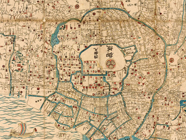
The shape of the moats as seen in the map was a unique characteristic of Edo. On the Edo ezu they can be seen depicted as bodies of water highlighted with a light blue color, spread all over the city. Upon close inspection of the map, it is clear that the moats extend outward from the center of the map where the Edo castle is located, in a clockwise spiral. This design is believed to be able to take advantage of the existing natural features, such as rivers, valleys, and hills, as the city grows and expands (Akira, 2003; Sorensen, 2002). At the same time, the spiral construction of the moats enables the city to grow without limitation, as there are no walls to restrict the development of the city.
Another notable feature of the Edo ezu is that the housing density is unevenly distributed. At the center of the spiral is the Edo castle, where housing density is the lowest. Housing density starts to increase disproportionately following a spiral shape as indicated by the moats. As individual houses are shown as white spaces, and the majority of them are rectangular and a smaller number depicted in irregular shapes, the housing density is clearly much lower in the neighborhood located in the upper left (or the southwest quarter of the city), as seen by the abundance of white space in that area. Housing density is higher in the neighborhood located to he upper right (or the northwest quarter of the city). The area beneath, or east of, the Edo castle has the highest housing density. The concentration of houses gradually decreases on the fringes of the city.
The final unique characteristic of the map is that it makes use of many small symbols marked by red dots. These symbols are mon, or the clan symbols, of the ruling class and are in different shapes and designs (Rotolo, 2013). Houses marked with mon are mostly clustered in the center of the city, to the south of the Edo castle. There are also a small number of houses with mon scattered elsewhere on the map.
The different housing densities and mon symbols are indications of social segregation between different social classes in Edo. Smith (2014) indicates that social hierarchy was important for people living in Edo, and that housing distribution was a key element that reflected such social hierarchy. Sand (2012) states that under the sankin kōtai regulation, daimyo owned a large amount of permanent estates in Edo, and that half of the city’s population was made up of military members such as samurai. In addition, Smith (2014) argues that daimyo and their servants inhabited a vast proportion of Edo, and that”most accounts of Edo emphasize the imbalance between a samurai population occupying 70 percent of the [Edo] urban area versus a chōnin [which is a social class that are mostly merchants] population of roughly the same size, squeezed into a mere 15 percent of the land. (Shrines and temples accounted for the remainder)” (Smith, 351).
The daimyo belonged to the elite class and had a higher social hierarchy than the middle class merchants. Such social hierarchy distinctions are presented on the Edo ezu. As mentioned earlier, houses occupied by daimyo are identified with red mon symbols, and since daimyo have a high social hierarchy, their houses are closer to the center of the city, in much less densely occupied areas. This southwest region of the city is also referred to as Yamanote, which is known as the upper class area (Ichikawa, 1994; Smith, 2014). In contrast, the eastern region and areas along the Sumida River on the Edo ezu have the highest housing density in the city. This region is known as Shitamachi, the residence of many chōnin. People living in this district were considered to be of lower social class (Ichikawa, 1994; Smith, 2014). In other words, members of the military ranks were more important and held more power, so their houses were closer to the center of the city and in more spacious regions, whereas merchants occupied a lower social class, meaning that their houses were much more clustered and further away from the city center. More importantly, the Edo castle, which symbolizes the highest power and highest social hierarchy, was located at the center of the city and holds the most prominent position on the map.
The impact of major political change can also be observed on the Edo ezu if compared with another map of Edo, the Suharaya Edo from 1854. On October 15, 1862, a major political change took place and a new regulation of sankin kōtai was implemented, which drastically reduced the mandatory residency time of daimyo in Edo (Smith, 2014). A large number of daimyo started to move out of Edo, and as suggested by Smith (2014), “the most immediate social consequence of the daimyo exodus was the dismissals of large numbers of servants …[and] those hired as military guards” (pp. 350-351). Moreover, houses in Edo were made with wood and were prone to fire and they did not hold much value, which were other factors behind daimyo exodus (Ichikawa, 1994; Sand, 2012). In fact, there were an estimated “91 fires that burned 15 blocks or more over a period of 234 years … [which means] a little more than one major fire every three years [took place in Edo]” (Sand, 2012, p. 38). Sand further explains that since houses were easily and frequently destroyed by fires, “houses were not considered to be legally attached to the land” (p. 46) and they held no value in terms of investment or hereditary possession. Hence, by comparing the Edo ezu with the map of Edo in 1854, one significant change is the reduced amount of mon symbols on the Edo ezu. The most important difference is that the mon symbol inside the Edo castle is missing on the Edo ezu, suggesting that the castle was no longer occupied by the shogunate in 1864. Many of the mon symbols are also missing in houses that are located far away from the castle, indicating that the officials who lived there in 1854 had moved out. This reduction of clan symbols on the Edo ezu is consistent with the political changes of the time, and indicated the waning power of the shogunate.
In 1868, Edo was selected to become the new capital of Japan, and “as a centre for concentration of human activities, convenient accessibility to other areas was one of the most significant factors in selecting the site of a city and to allow the possibility of future expansion into a large urban settlement” (Ichikawa, 1994, p. 193). Edo was given the name Tokyo, and it continued to grow as one of the largest and most populated cities in the modern world.
Works Cited
Allinson, G. D. (1978). Japanese cities in the industrial era. Journal of Urban History, 4(4), 443-476.
Ichikawa, H. (1994). The evolutionary process of urban form in Edo/Tokyo to 1900. The Town Planning Review, 65(2), 179-196.
Kikuya, K. (1864). Edo ezu. University of British Columbia Library. Retrieved from https://open.library.ubc.ca/collections/tokugawa/items/1.0222990#p0z-7r270f:Edo%20Ezu
Kominz, L. (2003). Tokyo. In The Oxford Encyclopedia of Theatre and Performance. Oxford: Oxford University Press. Retrieved from http://www.oxfordreference.com.ezproxy.library.ubc.ca/view/10.1093/acref/9780198601746.001.0001/acref-9780198601746-e-3950
Naito, A. (2003). Edo and Edo Castle – Developing a metropolis. From old Edo to modern Tokyo: 400 years. NIPPONIA, 25. Retrieved from http://web-japan.org/nipponia/nipponia25/en/feature/index.html
Rotolo, P. (2013). Mapping social hierarchies onto the city of Edo. Osher Map Library: Smith Center for Cartographic Education. Retrieved from http://www.oshermaps.org/exhibitions/map-commentaries/social-hierarchies-edo
Sand, J. (2012). Property in two fire regimes: From Edo to Tokyo. In C. Shammas (Eds.), European Expansion and Indigenous Response, Volume 11: Investing in the Early Modern Built Environment: Europeans, Asians, Settlers and Indigenous Societies (pp. 35-66). Boston: Brill. Accessed from http://site.ebrary.com/lib/ubc/detail.action?docID=10590545
Smith, H. D. (2014). The Edo-Tokyo transition: In search of common ground. In M. B. Jansen & G. Rozman (Eds.), Japan in Transition: From Tokugawa to Meiji (pp. 347-374). Princeton: Princeton University Press. Accessed from http://muse.jhu.edu.ezproxy.library.ubc.ca/books/9781400854301
Sorensen, A. (2002). The Making of Urban Japan: Cities and Planning from Edo to the Twenty-First Century. New York: Routledge. Accessed from http://lib.myilibrary.com.ezproxy.library.ubc.ca/Open.aspx?id=13794
Suhara-Ya Edo, Japan. (1854). Osher Map Library: Smith Center for Cartographic Education. Retrieved from http://www.oshermaps.org/search/zoom.php?no=12839.0001
Contributor: Xin Zhao
(Edited by Elle Marsh)

You must be logged in to post a comment.